Friday, December 31, 2010

Trapped!


Each of my right side windows is packed with snow. [And I just realized...it's because the right side windows are the only ones with screens, which catch thesnow and don't let it fall out!]

Well, the headline is a bit overdramatic, we're not really trapped here in Cheyenne. My dad's got a truck - though it doesn't have 4-wheel drive - and the wind has blown most of the snow off the roads.

In any event, we've got food here for a couple of weeks (and more importantly I have Pepsi.) But I expect things will be back to normal in a few days. The main thing about the weather is that the wind is just blowing the snow horizontally across the ground, which makes being outside in it extremely unpleasant.

Here's some photos from my house. I live on the ground floor of the two story house.

You can't really see the snow blowing across the ground, but that's what it's doing. So there's a drift of snow right in front of the house, but only a bit of snow covering our yard. I've got three sets of windows in my bedroom (this house has a lot of windows), the left side of each window is clear, the right side, as you see, has snow packed in it.


The drift just outside the front door


Sunday, December 26, 2010

Difference Between the American Legion and the VFW


Sign


Merci (Thank You) Train


Horse head hitching posts


That darn sun...will go for a better photo on a cloudy day!

I was out taking photos today, hoping that on a Sunday I'd be able to take photos of various businesses without a lot of cars in front of them. And for the most part it was true, but as usual after 15 minutes of taking photos I got bored and had to do something else.

So I drove into downtown Cheyenne to buy some stuff at Barnes and Noble, with my gift card I got yesterday. However, since I was going to downtown Cheyenne I took a side trip onto East Lincolnway. On the right side of this road, at exactly a mile, is the Cheyenne Motel and the Firebird Motel.

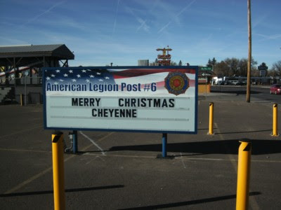
After the Firebird Motel is a gigantic complex, American Legion Post #6. To one side of the parking lot is a fenced in box car, a Merci Train box car, one of which was sent by France in 1949 to every state then in the Union.

There's a VFW out by where I live, in what is South Cheyenne or Orchid Valley (why Orchid Valley I have no idea, since I have yet to see any orchids), but it's a teeny tiny thing...at least 3 of it could fit into this American Legion Post #6.

So what's the difference between the American Legion and the American Veterans of Foreign Wars (VFW)?

The American Legion
The American Legion is a congressionally chartered mutual-aid veterans organization of the United States armed forces founded to benefit those veterans who served during a wartime period as defined by the United States Congress. The American Legion was founded in 1919 by veterans returning from Europe after World War I, and was later chartered under Title 36 of the United States Code. The organization is headquartered in Indianapolis, Indiana and also has offices in Washington D.C. The group has nearly 3 million members in over 14,000 Posts worldwide.

In addition to organizing commemorative events and volunteer veteran support activities, the American Legion is active in U.S. politics. While its primary political activity is lobbying on behalf of the interests of veterans and service members, including support for veterans benefits such as pensions and the Veterans Affairs hospital system, it has also been involved in more general political issues.

At the state level, the American Legion is organized into "departments", which run annual civic training events for high school juniors called Boys State. Two members from each Boys State are selected for Boys Nation. The American Legion Auxiliary runs Girls State and Girls Nation. The American Legion also hosts many social events.

General Douglas MacArthur, Presidents Harry Truman, Dwight Eisenhower, John F. Kennedy, Lyndon B. Johnson, Gerald Ford, Jimmy Carter, George H. W. Bush and George W. Bush were all members of The American Legion.

Organizational structure
Posts

The Post is the basic unit of the Legion and usually represents a small geographic area such as a single town or part of a county. There are roughly 14,900 posts in the United States. The Post is used for formal business such as meetings and a coordination point for community service projects. Often the Post will host community events such as bingo, Hunter breakfasts, holiday celebrations, and available to the community, churches in time of need. It is also not uncommon for the Post to contain a bar open during limited hours. A Post member is distinguished by a navy blue garrison cap with gold piping.

Counties
Each U.S. county comprises several Posts and oversees their operations, led by a County Council of elected officers. The County Commander performs annual inspections of the Posts within their jurisdiction and reports the findings to both the District and the Department level. A County Commander is distinguished by a navy blue garrison cap with white piping.

Districts
Each Department is divided into Divisions and/or Districts. Each District oversees several Posts, generally about 20, to help each smaller group have a larger voice. Divisions are even larger groups of about four or more Districts. The main purpose of these "larger" groups (Districts — Divisions) are to allow one or two delegates to represent an area at conferences, conventions, and other gatherings, where large numbers of Legionnaires may not be able to attend. A District Commander is distinguished by a navy blue garrison cap with a white crown and gold piping.

Departments
The Posts are grouped together into a state level organization known as a Department for the purposes of coordination and administration. There is a total of 55 Departments; one for each of the 50 states, the District of Columbia, Puerto Rico, France, Mexico, and the Philippines. Canada was merged into Department of New York several years ago. The three Departments located overseas are intended to allow active duty military stationed and veterans living overseas to be actively involved with the American Legion similar to as if they were back in the states. The Department of France consists of 29 Posts located in 10 European counties, the Department of Mexico consists of 22 Posts located in Central America, and the Department of Philippines covers Asia and the Pacific Islands. A Department Officer or Department Executive Committee Representative is distinguished by a white garrison cap with gold piping.

National headquarters
The main American Legion Headquarters is located on the Indiana World War Memorial Plaza in Indianapolis. It is the primary office for the National Commander and also houses the historical archives, library, Membership, Internal Affairs, Public Relations, and the Magazine editorial offices. The Legion also owns a building in Washington D.C. that contains many of the operation offices such as Economics, Legislative, Veterans Affairs, Foreign Relations, National Security, and Media Relations, and etc. A National Officer or National Executive Committee Representative is distinguished by a red garrison cap with gold piping.


The VFW
The Veterans of Foreign Wars of the United States (VFW) is a congressionally chartered war veterans organization in the United States. Headquartered in Kansas City, Missouri, VFW currently has 1.5 million members belonging to 7,644 posts, and is the largest American organization of combat veterans.

Members must be a US citizen or national with an honorable discharge from the US Armed Forces or currently serving in the United States Air Force, Army, Coast Guard, Marine Corps, or Navy. Membership also requires military service overseas during an operation or conflict and decoration with an expeditionary medal, a campaign medal or ribbon. A Leave and Earnings Statement showing receipt of Hostile Fire or Imminent Danger Pay is also acceptable proof for membership eligibility.

History
Historic marker commemorating the founding of the VFW in Pittsburgh.The VFW became a government-chartered non-profit organization by an act of the United States Congress on May 28, 1936;[3] as such, it receives no funding from United States tax receipts and is supported by charitable donations.

The first VFW was founded in Denver, Colorado in 1899 and officially "VFW Post 1, John S. Stewart Post". There are two other Post, which try to claim being Post 1, however the VFW National organization recognizes VFW Post 1 (www.vfwpost1.org) in Denver, CO as the first VFW Post. The current VFW was first formed in 1914 from the merger of two prior veterans organizations which both arose in 1899: the American Veterans of Foreign Service and the National Society of the Army of the Philippines. The former was formed for veterans of the Spanish–American War, while the latter was formed for veterans of the Philippine–American War.

VFW works on behalf of American veterans by lobbying Congress for better veterans' health care and benefits. The VFW also maintains a nationwide organization of employees and volunteers to assist veterans with their VA disability claims.[5]

VFW also donates millions of dollars and millions of hours for community service.[6] One of their most popular programs, Operation Uplink, provides free phone cards to overseas service members.

The current Commander of the VFW is Richard L. Eubank.

Involvement
Direct community involvement is a VFW priority, extending beyond the realm of veterans helping veterans.

Annually, VFW and the Men's and Ladies Auxiliaries donate more than 13 million volunteer hours of community service.[8] VFW members mentor youth groups, help in community food kitchens, volunteer in blood drives and visit hospitalized veterans. Others help veterans file compensation claims.

VFW's Community Service programs are designed to encourage community service and increase civic pride, which ultimately enhances education, improves the environment and ensures the availability of health services for our nations veterans.

VFW's Citizenship Education program is designed to stimulate interest in America's history and traditions and to promote citizenship, civic responsibility and patriotism.

VFW's Youth Scholarship programs provide more than $3.5 million in scholarships to our nation's youth. They include Voice of Democracy, Patriot's Pen youth essay contest and Scout of the Year.

The VFW's partnership with the Boy Scouts of America includes the sponsoring of more than 1,200 Scouting units with 40,000 members across the nation.

VFW's Safety Program encourages VFW Posts and Auxiliaries to conduct programs in home, auto and bicycle safety, as well as programs dealing with drug awareness and substance abuse.

The VFW National Home for Children is a community development in a family-like environment that is home to orphaned or single parent children of VFW or Ladies Auxiliary members. The home, which was established in 1925 on 160 acres in Eaton Rapids, Mich., emphasizes the values of education, good work habits and sound moral character.

Friday, December 24, 2010

Merry Christmas

It's coooold here in Cheyenne, and there's supposed to be snow tomorrow, Christmas day.

I wish I could be watching some football as the day goes on, but we've got DirectTV Satellite and we don't get the local channels - NBC, ABC or CBS. Utterly ridiculous!

Relatives are supposed to be here around 1 pm.... we'll play cribbage and eat food.

The Cheyenne Connecting Point website continues to take shape.

http://cheyenneconnectingpoint.com

Wednesday, December 22, 2010

22 Dec, 2010, Wednesday: Food Prices at Walmart

I've decided to go about documenting the prices at Walmart on a systematic basis, starting at the very right hand rear of the store, and going through the groceries.

Purpose? Well, to document the prices at the Walmart in Cheyenne on specific days, so people around the country can compare it with the price of their Walmart. Also to document what kind of brands the Cheyenne Walmart carries. I think most of them are nationwide, and local brands take up just a little space. But, I'll cover that here.

So, here's prices as of 22 Dec 2010 on the following objects:

Sparboe Farms, the egg provider here in Cheyenne


More Sparboe Eggs.


Great Value Chocolate Chip cookie dough


Where do Spardoe eggs come from?

http://www.sparboe.com/
From their website:
Company Overview
Initially, Sparboe Foods' main focus was producing unpasteurized tankers of liquid whole eggs. After a few years, we began branching out into other egg markets and in 2000, Sparboe Foods purchased our facility in New Hampton, Iowa along with a facility in Boyden, Iowa. The expansion gave Sparboe Foods the ability to grow, expand and be more responsive to our customers' needs. Today, we offer a variety of egg solutions to our customers.

Egg Solutions
We're dedicated to providing egg products that meet your exact specifications including various blends of products, unique packaging and sound delivery mechanisms to assure you always have high quality and low cost eggs in your finished products.

Integrated Supply Chain
We rely on our own operations at Sparboe Farms to supply us with our eggs. Sparboe Farms is one of the largest egg producing companies in the U.S. and a leader in Safe Quality Food Certifications, so you know your supply of eggs from Sparboe Foods is safe and secure.

Customer Focus
At Sparboe Foods, our customers are our priority. They know they can count on their dedicated Sparboe Foods sales team to give them one-on-one attention. And it shows. Our loyal customers keep coming back because they know we excel at meeting their precise specifications with incredible service and a reliable supply of the freshest, highest quality eggs.

Monday, December 20, 2010

Stateline Oasis - HIghway 85 on the Colorado/Wyoming border

I've begun work on the Cheyenne Connecting Point website. To that end, I drove to the Wyoming/Colorado state line, turned around, then headed back toward Cheyenne. Purpose: to document all the businesses on the east side of the road. (Well, to get started doing it, as there are so many of them.)

First thing I saw, actually on the west side of the road, was the Stateline Oasis. Even though it's on the west side, I thought I'd share it here.

The state of Wyoming has no lottery, Colorado does. So if you want to get in on Powerball - that's the place to go. It's about 13 miles from Cheyenne, south on Highway 85.

Now, I don't recommend playing the lottery, it's a waste of money. But if you've got the money to spare...this is the place to go.

The Stateline Oasis is adjacent to a private home, and the sign for it isn't as big as you'd expect. Inside there are a few tables where you can have popcorn and coffee as you sit down and do scratchoffs. The proprietors, in the few minutes I was in there, were very nice.


From the road, the Stateline Oasis looks just like a normal house (indeed, it is adjaent to a home)


Pull into the driveway and you see it offers Powerball


I would have loved to have purchased a Green Hornet scratchoff - but they wanted $20 for it. I think not!

Very nearby this establishment, also on the west side of the road, and I think actually in Wyoming, was something called the Den. A "gentleman's" club, from the look of the sign - which I do not reproduce here. But in the spirit of inclusiveness - I talk about everything in Cheyenne and environs, I tell you about it here.

Monday, December 13, 2010

Regional Food: Cornbread Mixes


I come from Yorktown, Virginia, and have only been living in Cheyenne for the last month or so.

When I lived in Yorktown, I really didn't do a lot of shopping at my local Walmart for certain kinds of foods - as for example cornbread mixes.

Nevertheless, I'm pretty sure that the Texas Style Cornbread mix was not available in my Walmart in Yorktown, but here it is in the Cheyenne Walmart.

As for the Marie Callender mix, Marie Callendar does seem to be a national brand, so it was probably in the Yorktown Walmart as well.

I don't remember that a "Mexican cornbread" mix was available in Yorktown, either, but it might have been.

Prices current as of Dec 13, 2010.

Recycle and Trash Outside KMart


There's a K-Mart on Dell Range Boulevard (the main drag through Cheyenne - it's got a Barnes & Noble, a Walmart, a Target, A Sams Club, etc. etc) and in their driveway there are several large blue containers for recycling - glass, plastic, cardboard and so on. Even a container for plain old trash.

It's free to deposit stuff there, so try to recycle if you can.

Friday, December 10, 2010

Yellowstone National Park


Grand Canyon of Yellowstone

Continuing with Lavinia Dobler's I Didnt Know That About Wymoing (1984) she continues her list of firsts with the first, and largest, national park in the US, which is located in Wyoming (with bits of it in Montana and Idaho), Yellowstone National Park.

The park consists of more than 2 million acres, comprising mountains, lakes and waterfalls, as well as therman springs and geysers, and over 260 species of animal and bird life (including bears!)

President Ulysses S. Grant sign ed the bill on March 1, 1872 to create Yellowstone National Park. (IN other words, this National Park was created before the first National Monument - the Devil's Tower.)


1938 tourist poster


A bit of history from Wikipedia:
There was considerable local opposition to the Yellowstone National Park during its early years: some locals feared that the regional economy would be unable to thrive if there remained strict federal prohibitions against resource development or settlement within park boundaries; local entrepreneurs advocated reducing the size of the park so that mining, hunting, and logging activities could be developed[23] and numerous bills were introduced into Congress by Montana representatives who sought to remove the federal land-use restrictions.

After the park's official formation, Nathaniel Langford was appointed as the park's first superintendent in 1872. He served for five years but was denied a salary, funding, and staff. Langford lacked the means to improve the land or properly protect the park, and without formal policy or regulations, he had few legal methods to enforce such protection. This left Yellowstone vulnerable to poachers, vandals, and others seeking to raid its resources. He addressed the practical problems park administrators faced in the 1872 Report to the Secretary of the Interior and correctly predicted that Yellowstone will become a major international attraction deserving the continuing stewardship of the government.

In 1875, Colonel William Ludlow, who had previously explored areas of Montana under the command of George Armstrong Custer, was assigned to organize and lead an expedition to Montana and the newly established Yellowstone Park. Observations about the lawlessness and exploitation of park resources were included in Ludlow's Report of a Reconnaissance to the Yellowstone Nation Park. The report included letters and attachments by other expedition members, including naturalist and mineralogist George Bird Grinnell. Grinnell documented the poaching of buffalo, deer, elk and antelope for hides. "It is estimated that during the winter of 1874–1875, not less than 3,000 buffalo and mule deer suffer even more severely than the elk, and the antelope nearly as much."

As a result, Langford was forced to step down in 1877. Having traveled through Yellowstone and witnessed land management problems first hand, Philetus Norris volunteered for the position following Langford's exit. Congress finally saw fit to implement a salary for the position, as well as to provide a minimal funding to operate the park. Norris used these funds to expand access to the park, building numerous crude roads and facilities.

In 1880, Harry Yount was appointed as a gamekeeper to control poaching and vandalism in the park. Yount had previously spent a number of years exploring the mountain country of present-day Wyoming, including the Grand Tetons, after joining Dr. Hayden’s Geological Survey in 1873. Today, he is considered the first national park ranger, and Younts Peak, located at the head of the Yellowstone River, was named in his honor. However, these measures still proved to be insufficient in protecting the park, as neither Norris, nor the three superintendents who followed, were given sufficient manpower or resources.

The Northern Pacific Railroad built a train station in Livingston, Montana, connecting to the northern entrance in the early 1880s, which helped to increase visitation from 300 in 1872 to 5,000 in 1883.[32] Visitors in these early years were faced with poor roads and limited services, and most access into the park was on horse or via stagecoach. By 1908 visitation increased enough to also attract a Union Pacific Railroad connection to West Yellowstone, though rail visitation fell off considerably by World War II and ceased around the 1960s. Much of the railroad line was converted to nature trails, among them the Yellowstone Branch Line Trail.

During the 1870s and 1880s Native American tribes were effectively excluded from the national park. A number of tribes had made seasonal use of the Yellowstone area, but the only year-round residents were small bands of Western Shoshone known as "Sheepeaters". They left the area under the assurances of a treaty negotiated in 1868, under which the Sheepeaters ceded their lands but retained the right to hunt in Yellowstone.

The United States never ratified the treaty and refused to recognize the claims of the Sheepeaters or any other tribe that had made use of Yellowstone. The Nez Perce band associated with Chief Joseph, numbering about 750 people, passed through Yellowstone National Park in thirteen days during late August, 1877. They were being pursued by the U.S. Army and entered the national park about two weeks after the Battle of the Big Hole. Some of the Nez Perce were friendly to the tourists and other people they encountered in the park, some were not. Nine park visitors were briefly taken captive. Despite Joseph and other chiefs ordering that no one should be harmed, at least two people were killed and several wounded.[34][35] One of the areas where encounters occurred was in Lower Geyser Basin and east along a branch of the Firehole River to Marys Mountain and beyond.

That stream is still known as Nez Perce Creek.[36] A group of Bannocks entered the park in 1878, alarming park Superintendent Philetus Norris. In the aftermath of the Sheepeater Indian War of 1889, Norris built a fort for the purpose of preventing Native Americans from entering the national park.

Wednesday, December 8, 2010

Devil's Tower


This photo taken in 1900.

If you've seen Close Encounters of the Third Kind, you've seen Devil's Tower. I'll be visiting it next year, but for now I include it here because it's part of Lavinia Dobler's I Didn't Know That About Wyoming (1984).

If you're planning a trip, you can wait until I give you full details, hopefully in spring of next year, or check out their website at:
http://www.nps.gov/deto/index.htm

From Wikipedia:

Recent history
Fur trappers may have visited Devils Tower, but they left no written evidence of having done so. The first documented visitors were several members of Captain W. F. Raynold's 1859 Yellowstone Expedition. Sixteen years later, Colonel Richard I. Dodge led a U.S. Geological Survey party to the massive rock formation and coined the name Devils Tower. Recognizing its unique characteristics, Congress designated the area a U.S. forest reserve in 1892 and in 1906 Devil's Tower became the nation's first National Monument.

The 1977 movie Close Encounters of the Third Kind used the formation as a plot element and as a location for its contact scene and climactic scenes.

Climbing
In recent years, climbing Devils Tower National Monument has increased in popularity. The first known ascent of Devils Tower by any method occurred on July 4, 1893, and is accredited to William Rogers and Willard Ripley, local ranchers in the area. They completed this first ascent after constructing a ladder of wooden pegs driven into cracks in the rock face. A few of these wooden pegs are still intact and are visible on the tower when hiking along the 1.3-mile (2.1 km) Tower Trail at Devils Tower National Monument.

Over the following thirty years many climbs were made using this method before the ladder fell into disrepair. The man most famous for climbing the tower is Fritz Wiessner who summited with William P. House and Lawrence Coveney in 1937. This was the first ascent using modern climbing techniques. Wiessner led the entire climb free, placing only a single piece of fixed gear (piton) which he later regretted, deeming it unnecessary.

Today hundreds of climbers scale the sheer rock walls of Devils Tower each summer. The most common route is the Durrance Route which was the second free route established in 1938. Today there are many established and documented climbing routes covering every side of the tower, ascending the various vertical cracks and columns of the rock. The difficulty of these routes range from relatively easy to some of the hardest in the world. All climbers are required to register with a park ranger before and after attempting a climb.

The Tower is sacred to several Native American Plains tribes, including the Lakota Sioux, Cheyenne and Kiowa. Because of this, many Indian leaders objected to climbers ascending the monument, considering this to be a desecration. The climbers argued that they had a right to climb the Tower, since it is on federal land. A compromise was eventually reached with a voluntary climbing ban during the month of June when the tribes are conducting ceremonies around the monument. Climbers are asked, but not required, to stay off the Tower in June.

According to the PBS documentary In the Light of Reverence, approximately 85% of climbers honor the ban and voluntarily choose not to climb the Tower during the month of June. However, several climbers along with the Mountain States Legal Foundation sued the Park Service, claiming an inappropriate government entanglement with religion.

Monday, December 6, 2010

The Black-footed Ferret


It was a sunshiney day today in Cheyenne, Wyoming, and more importantly, there was no wind. No wind! Stranger still, this is the second day in a row that there has been no wind! I am so happy I can't tell you!

This happiness caused me to forget to bring my camera with me, on the 15 mile/15 minute drive into Cheyenne, so no photos today. What I did do was go to the library and check out some books on Wyoming history.

And thus I start with The Black-Fotted Ferret. According to I Didn't Know That About Wyoming, by Lavinia Dobler, published in 1984, the Black-footed Ferret is the rarest animal in North America.

"The only known black-footed ferret colony is located west of Meeteetse in Park County."

The creature was first noted down in a book by James Audobon in 1851.

This ferret's chief food is the prairie dog.

Now, let's move to 26 years later and see the fate of the black footed ferret.

From Wikipedia:
The last known wild population was taken into captivity in 1985, a few years after its accidental discovery in Meeteetse, Wyoming. Release of captive animals has successfully re-introduced the species to parts of its former habitat, and currently these populations have made what has been called an "astonishing comeback.

They are nocturnal and primarily hunt for sleeping prairie dogs in their burrows. Though they will also eat mice and other small mammals, birds, and insects, a single Black-footed ferret eats about 100 prairie dogs a year and cannot survive without access to large colonies of them. Typically a prairie dog colony 125 acres in size will provide a sufficiently stable prey population for one adult ferret. The ferrets are mainly dependent on the prairie dogs for their survival, and even shelter in prairie dog burrows during the day. In the wild, black-footed ferrets spend about 99 percent of their time underground. Ferret mating seasons last from March–April. Gestation of the kits commonly lasts 41–43 days. The number of kits born ranges from 1 to 7, but most commonly only 3 or 4 are born.

The loss of their prairie grassland habitat, the drastic reduction of prairie dog numbers (through both habitat loss and poisoning), and the effects of canine distemper and sylvatic plague (similar to bubonic plague) have all contributed to the near-extinction of the species during the 19th and 20th centuries. Even before their numbers declined, Black-footed Ferrets were rarely seen: they weren't officially recognized as a species by scientists until 1851, following publication of a book by naturalist John James Audubon and Rev. John Bachman. Even then, their existence was questioned since no other Black-footed Ferrets were reported for over twenty years.

Black-footed Ferret kitsIn 1981, a very small population of about 130 animals was discovered near Meeteetse, Wyoming. Soon after discovery, the population began a rapid decline due to disease. By 1986, the Wyoming Game and Fish Department led a cooperative program to capture the 12 remaining animals (which would be added to an existing 6 already in captivity) and begin an intensive captive breeding program. At that time, the entire world population amounted to about 50 individuals in captivity.

As of 2007, the total wild population of Black-footed Ferrets was well over 750 individuals (plus 250 in captivity) in the US.

The recovery plan calls for the establishment of ten or more separate, self-sustaining wild populations. Biologists hope to have 1500 Black-footed Ferrets established in the wild by 2010, with at least 30 breeding adults in each population. Meeting this objective would allow the conservation status of the species to be downgraded to threatened.

Thursday, December 2, 2010

Gear Up For Cheyenne Frontier Days

Cheyenne Frontier Days for 2011 stars on Tuesday, July 19 and lasts until Sunday, July 31

There's a rodeo, Western entertainment and museum displays, and lots of fun.

http://www.cfdrodeo.com/events/index.aspx

According to Trib.com:
Cheyenne Frontier Days, Wyoming bullfighter win major PRCA awards
LAS VEGAS -- Cheyenne Frontier Days has received the Professional Rodeo Cowboys Association's Large Outdoor Rodeo of the Year award while Meeteetse's Dusty Tuckness has been named Bullfighter of the Year.

Cheyenne Frontier Days won for the seventh consecutive year and 12th time overall.

Cheyenne Frontier Days and the Pendleton Round-Up tied for the award, according to a PRCA media release issued today.

Tuckness also works the College National Finals Rodeo each June at the Casper Events Center.

The awards were presented Wednesday night at the National Finals Rodeo awards banquet in Las Vegas.

PRCA rodeo contract personnel, judges, clowns, stock contractors and contestants vote in October on the finalists for the awards.

Cheyenne Frontier Days previously received the Large Outdoor Rodeo of the Year award from 1993-96, 2000 and 2004-09.

Thursday, November 25, 2010

Cheyenne News, Nov 25, 2010

I've just discovered the Wyoming Tribune Eagle's website, called Wyoming News.com, and I must say there's not a lot there. Perhaps its in the beginning stages.

Anyway, for the local news, there are 3 stories. Count 'em, three. (I don't provide the links to the rest of each story, the idea is only to show a snapshot of what is going on in Cheyenne each day. The Wyoming News.com doesn't appear to be the best source, but I'll use it for now!

With your help, no Cheyenne family will go hungry this Christmas
Several fundraising efforts will help provide boxes full of groceries so that needy families can enjoy a holiday meal with all the trimmings.
More of this story

Cheyenne drivers hiding cell phones to dodge tickets
During a special operation, Cheyenne police officials found many drivers conceal their phones when they spot a marked police car, rather than obey the law.
More of this story

Man robs local bank, still at large
The suspect threatened to use a weapon, though he did not reveal one, during the robbery at Cheyenne State bank early Wednesday.
More of this story

Don't Drive and Talk (on your cellphone)

Wyoming News.com: Cheyenne drivers hiding cell phones to dodge tickets
During a special operation, Cheyenne police officials found many drivers conceal their phones when they spot a marked police car, rather than obey the law.

By Lindsey Erin Kroskob
lkroskob@wyomingnews.com

CHEYENNE -- Cheyenne drivers have made it clear that they would rather hide their cell phone when they spot a marked police car than avoid talking on the phone while driving.

The Cheyenne Police Department conducted a cell phone ban study last week to assess the severity of ordinance violation.

Of the 24 tickets issued last Friday, 21 were handed out by officers in unmarked vehicles.

"Clearly we see that the ordinance itself continues to be violated," Sgt. Rob Dafoe said. "Anyone driving around in an unmarked car or in their personal vehicle can see that people are still using their cell phones."

An officer sat in an unmarked car in the 400 block of West Lincolnway for two hours Nov. 18 to count the number of drivers using cell phones. In that time frame, 56 out of the 1,000 drivers, about 5.6 percent, were visibly using a cell phone.

Dafoe said that figure is a round average for the number of offenders.

"It was just to give us an idea," he said. "We are going to continue to study and provide increased enforcement as our resources allow."

The following day, three unmarked vehicles and one patrol car hit the streets for three to four hours to specifically cite cell phone ordinance violators.

Cheyenne Police Lt. Marti Allsop issued 11 tickets Friday. Ten out of the 11 drivers said they knew that talking on their cell phone was the reason they were being pulled over. One driver had a temporary license plate out of Colorado and wasn't aware of the ordinance.

Cheyenne Police Chief Brian Kozak said he was out with the enforcement team for about an hour Friday and issued three citations.

"Everyone that lives in the county knows about the ordinance," Kozak said. "It goes to show that it has been properly publicized."

He said the department is going to take a "zero tolerance" stance on cell phone ban enforcement.

But that doesn't come without its challenges.

"The majority of offenders live and work in the Cheyenne area," Dafoe said. "Too often these drivers have become kind of police smart."

He said drivers who choose to talk on their cell phones will keep an eye out for marked vehicles and either conceal the phone or quickly hang up.

Dafoe said it is human nature to slow down or make complete stops when a marked officer is visible, but "this seems to be more of an overt act to avoid compliance with the ordinance."

"That takes a very conscious effort," he said.

The department hopes to increase enforcement of the ordinance, but Dafoe said it's difficult to catch offenders with daily traffic enforcement units, which is about two to three officers on an average day.

These officers are required by law to drive clearly marked vehicles.

"Kids don't get into the cookie jar when mom is in the kitchen," Dafoe said. "It's a rock-and-a-hard-place scenario."

Adding unmarked vehicles to focus on cell phone violations would take additional funds out of the department's budget.

"It is very resource intensive," Dafoe said.

Kozak said they plan to do cell phone ban enforcement once a month if they can. The department did another compliance study Wednesday between 2 p.m. and 4 p.m. on Dell Range Boulevard. He said they also plan on getting the word out on the department's variable message boards around town.

"I think a lot of people might forget the hazards involved, and we want them to know that we are out there enforcing the law for good reason," Kozak said, adding that being able to focus on driving is key. "It's a split second and you could be in an emergency situation, and you need that time to react properly."

Wednesday, November 24, 2010

11 degrees and a windchill of who knows what?

I've mentioned that I've been driving relatives around for a while. My aunt Carol is staying with us, and today I took her to the Wyoming State Museum, located at 2301 Central Avenue in Cheyenne.

(Open Mon to Fri 9 am to 4.30 pm, Sat 10 am to 2. pm, closed Sundays)

Photos aren't allowed inside the museum, but I'll share exterior photos later on. I did not take exterior photos today because it was just too damn cold!

Anyway, a feature of this blog, as soon as I can find a place to give me the reliable info, will be to post highs and lows, temperature-wise, for every day of the year.

A travelling exhibit called Snoopy as the World War I Flying Ace will be at the musuem until November 27...which gives folks about 2 more days to see it, since it'll be closed tomorrow, Thanksiving. Oversize reproductions of several of the strips featuring Snoopy in his pilot gear, with expanatory placards giving history of Charles Schultz and why he decided to feature Snoopy against the Red Baron, and so on. (Since Schultz was born in Minneapolis, MN and died in California I don't know why the Wyoming State Museum has this exhibit, but it's a lot of fun. I've never cared for the Peanuts comic strip - I don't like sad sack characters like Charlie Brown - and most of the time I don't like Snoopy, except in his guise as the WWI flying ace.

Tuesday, November 23, 2010

A Man and his Pet


I have returned to Cheyenne after a week long trip visiting relatives.

Serious posts in this blog begin tomorrow.

For now...above is a fun photo from South Dakota, west of Murdo which has the big antique car museum. It's a skeletal dinosaur...led by a skeletal man.

Wednesday, November 17, 2010

Odessa Meteor Crater, Odessa, TX

A few days ago, I took what I expected to be a 4 day trip at the most. A drive down to Sweetwater, Texas to attend the first annual WASP Museum 5K Run fundraiser, than a visit to my relatives in Burleson, TX, then back up to Cheyenne.

But my aunt asked me to take her to visit her sister (my other aunt) in Box Elder, SD, and then to take her to see my mom, now in Cheyenne, and then back down to Burleson. Since I love to drive, and she offered to split costs, I said yes. But, that means my trip has been extended by several days. I'm currently in Shamrock, TX.

Here are a few photos of the Odessa Meteor Crater in Odessa, Texas.


And here's the write up from Wikipedia:
The Odessa Meteor Crater is a meteorite crater in the southwestern part of Ector County, southwest of the city of Odessa, Texas, United States. It is located approximately 3 miles (5 km) south of I-20 at FM 1936 south.[1] This is one of two impact crater sites found in Texas, the other being the much larger and older Sierra Madera crater.

The Handbook of Texas Online describes the Odessa meteor crater as the largest of several smaller craters in the immediate area that were formed by the impact of thousands of octahedrites (an iron metallic type) that fell in prehistoric times.[2]

The web site of the University of Texas of the Permian Basin (UTPB, Center for Energy and Economic Diversification (CEED)), identifies five craters at the Odessa site and shows a distribution map of the meteorite fragments recovered from the area.

The recoveries have generally come from an area to the north and northwest of the main crater site, with only a few found to the south. They indicate that the structure of the main crater, because it was one of the earliest to be recognized and studied, is now used to name similar impact sites on a worldwide basis. Over 1500 meteorites have been recovered from the surrounding area over the years, the largest of which weighed approximately 300 pounds (135 kg), but excavations in the main crater confirm that there is no meteorite mass underground and probably never has been. The site has been designated as a National Natural Landmark by the National Park Service, and a small information area and nature trail has been set up on-site for a self-guided tour.

It is 168 meters (~550 feet) in diameter and the age is estimated to be around 63,500 years (Pleistocene or younger). The crater is exposed to the surface, and was originally about 100 feet (30 meters) deep. Due to subsequent infilling by soil and debris, the crater is currently 15 feet (5 meters) deep at its lowest point, which provides enough relief to be visible over the surrounding plains, but does not offer the dramatic relief found at the more famous Meteor Crater in Arizona.

Still, the site offers an excellent opportunity to view a relatively uncommon impact feature close to a major transportation artery near a major city.

Tuesday, November 16, 2010

Kit Carson Trading Post


Cheyenne is located in the southeast corner of the state, and its a 5 minute drive into Colorado.

I'm currently on travel, in Texas, and did not bring my camera cord so I could download photos. So apologies for not being to upload lots of photos.

Here is a photo of the Kit Carson Trading Post, located in the tiny town of Kit Carson, Colorado.

Thursday, November 11, 2010

Two views from the deck of my new house


When I lived in Minneapolis, MN, nothing stopped people from going to work in winter. An inch of snow, two inches, six inches, a foot? The snowplows were out at the first sight of a snowflake, and people were expected to bus or drive to work - and they did. (Of course, this was 20 years ago when the city had the money to have snowplows running constantly, I haven't lived there for 10 years and with the new austerity drive that cities are engaged in...who knows?

Anyway, I don't know about Cheyenne. They must be used to snow (unlike Yorktown, VA where I've lived for the last 8 years, and where if it snowed a mere half inch, the entire city shut down) but I don't know if they have snowplows or if everyone here has a 4-wheel drive truck that they take out at times like these. (In the housing area in which I live, there seems to be an average of 4 vehicles in every yard - only two of which work. My closest neighbor has nine vehicles in his yard. Plus two horses and a sheep.)

Wednesday, November 10, 2010

The Boots of Cheyenne - Library Boot


A fund raising activity that a lot of cities in the USA took part in several years ago was to make scultptures - or casts, I suppose - of the town's "signature item", have artists paint them, then auction them off, and place them in areas around town.

Many years ago in St. Paul, MN it was Snoopy...and I remember how sad it was that many of these wonderfully painted statues were later vandalized by young punks with their grafitti cans, or even destroyed - heads ripped off.

In Norfolk, Virginia, it was the mermaid...in Kill Devil Hills, North Carolina it was a winged horse, and here in Cheyenne, it was the boot.

There are 18 boots in Cheyenne, and as this blog progresses I'll show each one.

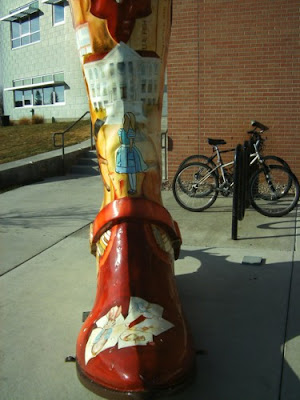
The Library Boot was painted by Max Larkin, and bought by the Laramie County Library [i.e. the taxpayers who fund the library!]. There are four sides to the boot - the left and right sides, the toe, and the... I suppose it's called the spine.

I only took photos of 3 of the 4 sides...forgetting about the spine...I don't actually think the spine was decorated on this one.

The buildings on the boots are old Cheyenne libraries, now superseded by this new one (see photo 1). On the toe are characters from Beatrix Potter, on the shaft of the boot is Alice.

Thursday, November 4, 2010

I'm settling in

I apologize for the paucity of posts to this blog. We arrived at our new house a couple of weeks ago, with all our boxes of books. But all the bookcases to put the books on were left in Virginia. Now they have arrived, and I've been busy unpacking.

I'll be posting pictures and info here on a regular basis starting tomorrow.

Tuesday, October 19, 2010

Brief bio of Cheyenne from Wikipedia

Cheyenne is the capital and largest city of the U.S. state of Wyoming and the county seat of Laramie County. It is the principal city of the Cheyenne, Wyoming, Metropolitan Statistical Area which encompasses all of Laramie County. The population is 57,618 at the 2010 census. Cheyenne is the northern terminus of the extensive and fast-growing Front Range Urban Corridor.

History
On July 5, 1867, General Grenville M. Dodge and his survey crew platted the site now known as Cheyenne in Dakota Territory (later Wyoming Territory). This site was chosen as the point at which the Union Pacific Railroad crossed Crow Creek, a tributary of the South Platte River. The city was not named by Dodge, as his memoirs state, but rather by friends who accompanied him to the area Dodge called "Crow Creek Crossing." It was named for the American Indian Cheyenne nation, one of the most famous and prominent Great Plains tribes closely allied with the Arapaho.

There were many from a hundred miles around who felt the construction of the Union Pacific Railroad through the area would bring them prosperity. By the time the first track was built into Cheyenne November 13, 1867, over four thousand people had migrated into the new city.

Those who did not leave with the westward construction of the railroad were joined by gamblers, saloon owners, thieves, opportunists, prostitutes, displaced cowboys, miners, transient railroad gangs, proper business men, soldiers from "Camp Cheyenne," (later named Fort D.A. Russell, now F.E. Warren Air Force Base), and men from Camp Carlin, a supply camp for fifteen northern army posts on the frontier

As the capital of the Wyoming Territory and the only city of any consequence, as well as being the seat of the stockyards where cattle were loaded on the Union Pacific Railroad, the city's Cheyenne Club was the natural meeting place for the organization of the large well-capitalized ranches called the Wyoming Stock Growers Association. (See Johnson County War of 1892, the largest of the "range wars" of early Wyoming history).

Geography & Climate
Cheyenne is located at 41°8′44″N 104°48′7″W / 41.14556°N 104.80194°W / 41.14556; -104.80194 (41.145548, -104.802042). Lying near the southeast corner of the state, it is one of the least centrally located state capitals in the nation (together with cities such as Carson City, Nevada and Juneau, Alaska).

According to the United States Census Bureau, the city has a total area of 54.9 km² (21.2 mi²). 54.7 km² (21.1 mi²) of it is land and 0.2 km² (0.1 mi²) of it (0.38%) is water.

Cheyenne, like most of the rest of Wyoming, is semi-arid (Koppen BSk). Winters are cold and moderately long, but relatively dry, with a January average of 25.9 °F (−3.4 °C), highs that fail to reach freezing occur 37 days per year, and lows dip to the 0 °F (−18 °C) mark on 12 nights.

However, the coldness is often interrupted, with chinook winds blowing downslope from the Rockies that can warm conditions, bringing the high above 50 °F (10 °C) on 20 days from December to February. Snowfall is greatest in March and April, averaging 60 inches (152 cm) for the season, yet thick snow cover rarely stays.

Summers are warm, with a July average of 67.7 °F (19.8 °C), and highs reaching 90 °F (32 °C) 8 times. Spring and autumn are quick transitions, with the median freeze dates being May 12 and September 26. The annual precipitation tends to be concentrated from May to August and is low during fall and winter, contributing to the area's 2980 hours (~68%) of the possible total, of sunshine per year.

At the 2005-2007 American Community Survey 3-Year Estimates, the city's population was 89.3% White (79.2% non-Hispanic White alone), 12.7% Hispanic or Latino (of any race), 4.5% Black or African American, 2.5% American Indian and Alaska Native, 2.1% Asian and 6.4% from some other race. 22.5% of the total population had a Bachelor's degree or higher.

As of the census of 2000, there were 53,011 people, 22,324 households, 14,175 families residing in the city, and 81,607 people residing in the Metropolitan Statistical Area making it the largest city and metropolitan area in the state of Wyoming. The population density was 969.6/km² (2,511.4/mi²). There were 23,782 housing units at an average density of 435.0/km² (1,126.7/mi²). The racial makeup of the city was 88.11% White, 2.78% Black or African American, 0.81% Native American, 1.06% Asian, 0.11% Pacific Islander, 4.44% from other races, and 2.69% from two or more races. 12.54% of the population were Hispanic or Latino of any race.

There were 22,324 households out of which 30.4% had children under the age of 18 living with them, 49.2% were married couples living together, 10.6% had a female householder with no husband present, and 36.5% were non-families. 31.3% of all households were made up of individuals and 10.6% had someone living alone who was 65 years of age or older. The average household size was 2.33 and the average family size was 2.93.

The median income for a household in the city was $38,856, and the median income for a family was $46,771. Males had a median income of $32,286 versus $24,529 for females. The per capita income for the city was $19,809. About 6.3% of families and 8.8% of the population were below the poverty line, including 11.1% of those under age 18 and 5.8% of those age 65 or over.

Government
Cheyenne's government consists of a mayor and a city council. The mayor is elected in a citywide vote. The city council has nine members each of whom are elected from one of three wards. Each ward elects three members.

Education
Primary and secondary schools

Public education in the city of Cheyenne is provided by Laramie County School District #1. The district is served by three high schools, Central High on the northwest side, East High on the east side, and South High on the south side.

Colleges and universities
Cheyenne is home to Laramie County Community College (LCCC) and Institute of Business & Medical Careers.

Economy
The state of Wyoming operates a multitude of offices in downtown Cheyenne. Many area residents are employed by or are dependent on the U.S. Air Force, through F.E. Warren Air Force Base to the west of the city, or by the Wyoming National Guard. Railroads remain a major economic force for the city, with both the Burlington Northern Santa Fe and Union Pacific employing many residents.

Steps have been taken in recent years to diversify the city's economy. Lowe's and Wal-Mart both operate distribution centers on the city's outskirts. Sierra Trading Post is headquartered in the city and also operates its distribution and fulfillment centers in the city.

Cheyenne's high elevation, coupled with its position on the continent, make it one of the windiest cities in America. The abundance of wind makes Cheyenne an opportune place to develop wind energy. Wind turbines are currently being placed around Laramie County.

Laramie County Community College is home to a leading wind energy technician program, where students learn to maintain these turbines. The opening of a Vestas wind turbine blade assembly in nearby Weld County, Colorado, as well as other alternative energy manufacturing facilities around Colorado, are transforming the region into a center for alternative energy.

Great Lakes Airlines and Taco John's are headquartered in Cheyenne.

Sunday, October 17, 2010

Manifesto

Cheyenne, Wyoming.

The who, what, when, where and why.